


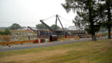
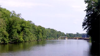
Lock 28B
Day 3
1:30 pm
Total Hrs: 16.75
Avg. Speed: 8
GPS:
43.047077
-77.085433

We had a nice lunch and a 1-hour break in Newark. (That's why the time of day says 1:30, but the Total Hours number hasn't changed.)
About 5 minutes after we got underway we came upon the lock. We asked the lock operator how long it would take us to get to Seneca Falls. "You'll be there around 4," said he.
Every map, booklet, guidebook, and even the GPS disagreed, but we figured he knew the canal better than any of those items. We figured wrong.


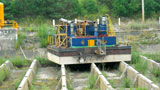
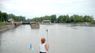
Lock 28A - The Drydock
Day 3
2:15 pm
Total Hrs: 17.5
Avg. Speed: 8
GPS:
43.062160
-77.019175
As I said before, the lock operators are some of the friendliest people on the planet.
There was no other traffic approaching, so this nice gentleman offered to let us tie off inside the lock so I could do my "Cappy Rick" thing (investigate the engineering and take pix & video of the drydock), and Fender T. Dog could do his thing (which we'll leave to your imagination).
The drydock is where they service the boats, dredges, tenders, and barges that service the canal. The chamber fills with water, the gates open, the equipment enters, the gates close, and the chamber is drained. I'm told this one is the largest of its kind on the canal system. It's at least four times the size of the drydock we saw in Lockport.
There were assorted pieces of equipment in drydock, but the one that caught my eye was the ancient dredge in the southeast corner. It looked like it had been sitting there for years. Forlorn? Like me, it wanted to be out on the high seas. (Or at least on the canal.)
The video shows the entire drydock.


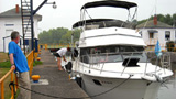


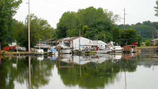
Miller's Marina
Day 3
2:30 pm
Total Hrs: 17.75
Avg. Speed: 8
GPS:
43.062542
-77.004141
When I saw the sign I thought it was Miller Time, but it turned out to be a full-service marina. Miller's Marina is just a couple of minutes east of Lock 28A on the north bank, but the elapsed time of day includes the time we spent locking through 28A.
I couldn't see the gas prices, but it's nice to know there is gasoline available at a full-service marina in this stretch of canal. The little booklet with the canal maps has icons showing gas stops, but several of those are no longer open.
I was facing aft to take the photo. When I turned around I had to immediately back off the throttles because ...

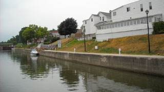
Lock 27 - Lyons
Day 3
2:36 pm
Total Hrs: 17.8
Avg. Speed: 8
GPS:
43.062305
-76.996299
... Lock 27 was right around the bend!
The downbound lock-through took about 11 minutes. When the gates opened we were surprised to see that the lock is adjacent to the wall at Lyons. You would think the turbulent discharge from the lock would cause all kinds of problems with boats that were moored to the wall, but it actually causes only a smooth, slow current. Keep in mind, too, that the lock shuts down for the night at 10 pm.
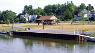
We didn't stop here, but I'm told the facilites are outstanding and pretty much everything you would need is within walking distance from the north wall. Even coffee, if you happen to remember that you have none.

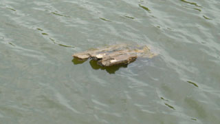
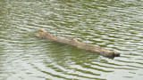
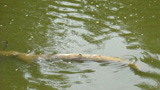
Deadhead City!
Day 3
3:15 pm
Total Hrs: 18.5
Avg. Speed: 8
GPS:
43.066861
-76.926040
The long stretch between Lyons and Clyde is a slightly wider, natural channel that incorporates the Clyde River. The banks are low with very little rise, and both sides of the channel are lined with trees and thick undergrowth. It's actually the northwestern edge of the Montezuma Wetlands. The channel tends to collect (natural) debris. The debris includes tree trunks, which float slowly with the very slight current. As they get waterlogged, one end of the tree trunk will sink to the bottom, leaving just a piece of the trunk exposed just above the waterline. These are called "Deadheads". They are hard to see, and they can take out a prop or shaft in a hurry!
When we first left Lock 27 I saw a very large deadhead in the center of the channel. I called Lock 27 to inform the operator so he could warn others. He said, "Thanks, Captain, but be advised that the channel is filled with debris from the recent storms all the way to the C&S Canal."
The exposed deadheads were easy to see. However, if they were just below the waterline there were only telltale differences in the wave patterns to broadcast their positions. Either way, spotting them required focus and concentration -- something I really didn't like. After all, I was supposed to be on vacation!


Clyde
Day 3
3:55 pm
Total Hrs: 19.2
Avg. Speed: 8
GPS:
43.080846
-76.870437
We passed Clyde and nearly missed it. There is a small wall on the south bank with two power and water towers and a nice little pavilion in the adjacent park. No facilities, however. The well-hidden town is across the bridge on the north bank. It doesn't seem likely that they'll be adding much in the future. The existing wall can't be expanded and the railroad that runs along the canal on the north would have to be moved farther from the canal to make room. Not gonna happen.

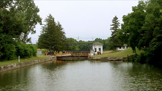
Lock 26
Day 3
4:15 pm
Total Hrs: 19.5
Avg. Speed: 8
GPS:
43.060224
-76.838700
According to our estimates we're still at least two hours from Seneca Falls. So much for "You'll be there around 4." We didn't care. We'll get there when we get there. That's what Life at 7 Miles Per Hour is all about!
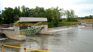
The Montezuma Swamp is a national wildlife refuge and part of the Montezuma Wetlands Complex. It drains all of the waters from Lyons to Syracuse, including Seneca and Cayuga Lakes, into Lake Ontario via the Oswego River.
Water management is critically important to this area, and they accomplish it with engineering marvels like this dam and sluice gate. The concrete and steel has been replaced, but the technology is the same as when it was designed nearly 100 years ago. The spillway keeps the pool level at the proper depth for lock operation. The sluice gate can be opened to prevent upstream flooding.
As we approached we noticed that both sets of lock gates were closed and the lock was empty. We had to wait for the lock to fill, but since the lift is only six feet it was just a few minutes. I asked the lock operator if they preferred to keep the locks empty with the gates closed. He said it didn't really matter whether the lock was full or empty, but they did keep the gates closed until traffic approached.
We noticed that he did close the gates after we cleared the lock.


The Montezuma Escort - A Most Incredible Thing!
Day 3
4:45 pm
Total Hrs: 20
Avg. Speed: 8
GPS:
43.025363
-76.803927
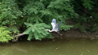
On the high seas it's good luck to see dolphins swimming along with your vessel. Almost as if they're saying "Follow us! We'll protect you!"
On the Erie Canal we hoped the same was true for Blue Herons. This one circled the boat, then landed just ahead of us. He would wait for us to catch up, then jump ahead another fifty yards and wait again, as if saying "Follow me! I'll show you the way!" We were amazed that he did this all the way to Lock 25 -- a distance of nearly three miles!
I grabbed the video camera and caught him as he came around behind the boat right after he introduced himself.

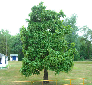
Lock 25 and the Catalpa Tree
Day 3
5:05 pm
Total Hrs: 20.3
Avg. Speed: 8
GPS:
42.998856
-76.762979
This lovely curiosity has been decorating the lawn at Lock 25 for ten years. It's called a Catalpa or Indian Bean Tree. The lock operator told us it blooms with incredibly beautiful yellow flowers similar to those found on a Trumpet Vine, then produces the bean-like seed pods that give the tree its colloquial name. He said the tree is home to several species of birds that nest inside its thick canopy. His only complaint is that it dumps thousands of seed pods on the lawn that are difficult to rake.
This section of the canal is not only unique because it meanders through the Montezuma Swamp. It is also one of the sections where the speed limit is raised to 30 miles per hour. I told Mia, "The only way No Losses will hit 30 is if someone tows us!"

The Cayuga-Seneca Canal
Day 3
5:25 pm
Total Hrs: 20.7
Avg. Speed: 8
GPS:
43.003015
-76.735948
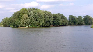
If you have binoculars, and if the trees and brush don't obscure it, you can see the sign on Kipp Island that directs you to the Cayuga-Seneca ("CS") Canal. Don't sweat it. If you miss this turn there's another one just ahead.
Until now, eastbounders have had green channel markers on the south (starboard) side. After you make the turn, red markers are starboard.
Water depth will scare you as you make the turn. No Losses reported 6 feet as she crossed the hump from the main channel into the CS. The depth increased as soon as we crossed over the hump. It was all good and safe.
Except for some really weird cows.

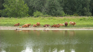
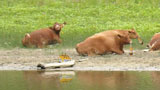
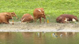
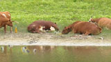
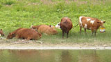
The Cow Party
Day 3
5:45 pm
Total Hrs: 21
Avg. Speed: 8
GPS:
42.982327
-76.734055
The CS Canal straightens the original path of the Seneca River, and it has been widened and deepened. The banks have a very low rise as the canal cuts directly through the Montezuma Swamp. It's obviously a man-made section and an almost perfectly straight shot from the Erie to the first lock, CS1.
I have always wondered what cows do when they are not being milked. Farmers turn them out to pasture and they disappear. Where do they go?
We passed this group about half a mile after the turn. There was no sign of civilization on either bank. No houses, no docks, no barns. The perfect cow getaway!
At first glance we thought they were just relaxing on the beach, but it turns out they were taking the Corona Beer commercials to heart.
(Do they have TVs in the barn?!?)
I saw no purses or wallets. And cows don't have pockets, do they? Where did they buy the beer? How did they pay for it?
After thinking about it for a few minutes, I came to the conclusion that they weren't that different from us.
They were also living the Great American Escape Fantasy.
I wanted to stop and have a beer or two with them but as I said, there was no dock.