


Lockport
Day 1
7:00 pm
Total Hrs: 3
Avg. Speed: 0
GPS:
43.171832
-78.691652

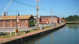
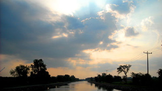
Average speed zero! Hah! That's because it took us 30 minutes to lock through 34 and 35.
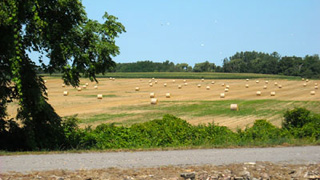
This is just below the locks. I had to snap a photo. Apparently the sign marks an observation stop on the walking tour.


7:01 pm
Avg. Speed: Idle
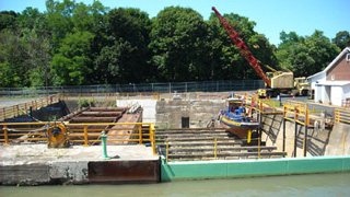
This drydock is just past the fallen rocks. It's used for servicing the barges, tugs, dredges and other working boats that maintain the canal system.
The green wall is actually a gate that opens when the drydock is flooded, allowing the equipment to enter and leave.

7:02 pm
Avg. Speed: Idle
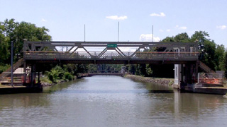
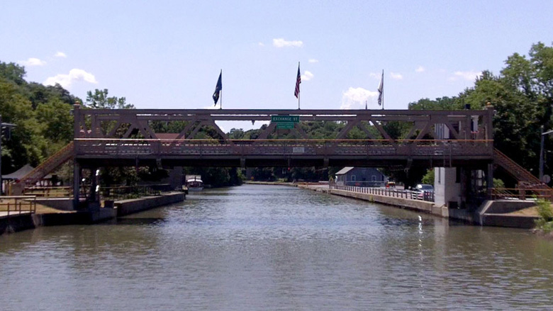
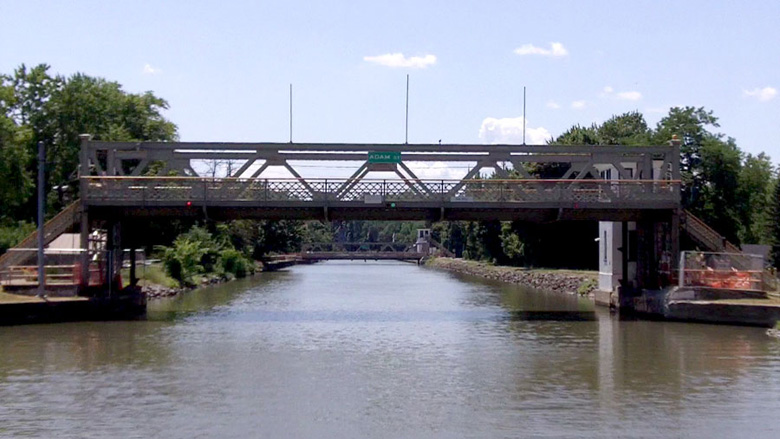
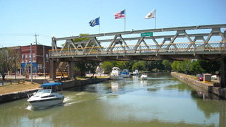
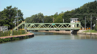
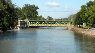
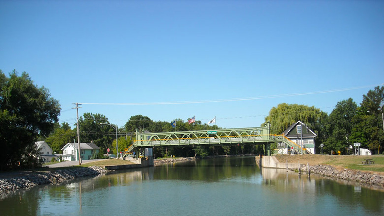
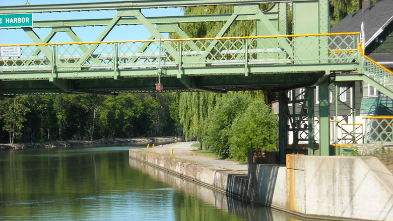
Eastbound boaters will immediately arrive at the Exchange Street lift bridge (upper right). Lift bridge operators monitor VHF Channel 13, but generally they know exactly when you're coming. They get updates from other operators and can monitor any boat's progress on their computers.
The Adam Street lift bridge (lower right) is only a hundred yards away. During the 2011 season it was closed to street traffic and locked in the up position for servicing.
The pics and video we took show the bridges from a westbound perspective.
At about the 25 second mark on the video you'll hear the old girl groan (the bridge, not the 1st Mate!). I'd be groaning too if I was 100 years old!


Matt Murphy
Day 1
7:06 pm
Total Hrs: 3.1
Avg. Speed: Idle
GPS:
43.182046
-78.677609
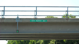
The Lake Ave. bridge. Also known as "Matt Murphy Way".
Now, being a guitar player for nearly all of my life I immediately thought of one of my earliest influences, Matt "Guitar" Murphy, who is probably best known to the masses as one of the guitarists (along with Steve Cropper) in the original Blues Brothers band and movie.
I thought, "Hey, that's really nice of the City of Lockport to recognize a musical legend!"
But it wasn't so. This particular Matt Murphy turned out to be a dead politician.

Wide Waters
Day 1
7:12 pm
Total Hrs: 3.2
Avg. Speed: Idle
GPS:
43.185976
-78.667009
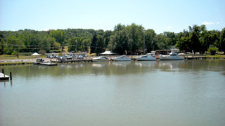
Wide Waters Marina supposedly has gas and pumpout, but since I didn't need either I beelined the channel.
Besides, if they do have services they keep them hidden. All I saw was a burger joint. I hear the ice cream is good, though.

Big Bird
Day 1
7:18 pm
Total Hrs: 3.3
Avg. Speed: 8
GPS:
43.188749
-78.660078
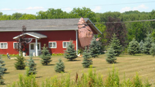
Okay. It's bad enough that some people put pink flamingoes on their lawns. Or plywood cutouts like "Man Leaning Against Tree Smoking Pipe". Or how 'bout the little jockey holding a lantern?
Heck, Rednecks use broken toilets and old sofas for planters on their lawns.
But I really have to question the thought process of these homeowners. In case you can't guess, it's a 20-foot sheet-metal chicken.
Mia said, "Cappy Rick, that's a rooster." How the heck can she tell?

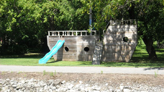
Failure to Launch
Day 1
7:30 pm
Total Hrs: 3.5
Avg. Speed: 8
GPS:
43.198232
-78.594361
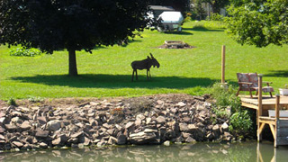
Here's another very strange lawn ornament.
At least this one has a purpose. Or had a purpose. I'm told the "kids" who live here are now in their late 20's.
Like the landlocked ship, they are experiencing a "Failure to Launch".

Gasport
Day 1
7:40 pm
Total Hrs: 3.7
Avg. Speed: 8
GPS:
43.199809
-78.574856
As money becomes available, Gasport is slowly making improvements to its wall -- south and west of the bridge -- and the surrounding grounds are well maintained.
There are now three power connections, although they appear to be 20-amp Edison. Water is available, but not for direct hookup.
There's really nothing within walking distance. A lady out for a stroll struck up a conversation and told us the little tavern across the street from the bridge operator's tower has the best roast beef sammiches in the area.
The Lift Bridge Operator asked us how far we'd be going so he could pass it along up the waterway. I told him we planned to overnight at Medina.
Lockport notwithstanding, this is really the first of the small-town "port" stops on the canal eastbound, and it's where we first discovered that people along this waterway are incredibly friendly.

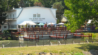
Basket Factory
Day 1
8:12 pm
Total Hrs: 4.2
Avg. Speed: 8
GPS:
43.212239
-78.483434
Just before Middleport on the south bank is the Basket Factory.
Although the sign says Restaurant and Marina, it's a restaurant with some docks. It's not a marina. Why would they lie?
Anyways ... I don't know if No Losses could make it in there with her 3-foot draft, but I do know the food is outstanding.
The southwestern skies looked threatening, so I cranked up the NOAA Weather Radio. Storms are a-comin'. Hope we can make it to Medina before they hit.

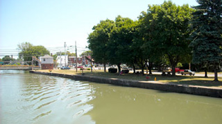
Middleport
Day 1
8:15 pm
Total Hrs: 4.25
Avg. Speed: 8
Skies: Overcast
Wind: Stirring
GPS:
43.213185
-78.475727
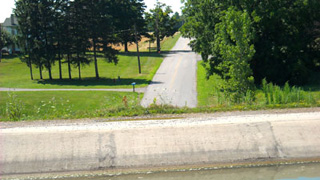
Plenty of space on both walls for boats. Ample power & water hookups.
The Basket Factory is a short (ten-minute?) walk, so it would be better to tie off at the wall rather than chance possible shallow water at the Basket Factory's "Marina".
The photo is deceiving because it was taken on the westbound (return) trip when the skies were clear on a beautiful summer day.
On the eastbound leg we were concerned about the approaching storm. The skies were now overcast, the wind was starting to stir, and it felt like Mother Nature was about to cut loose. Fender T. Dog even decided to head into the cabin, abandoning his usual haunt on the aft deck.

Somewhere between Middleport and Medina
Day 1
8:36 pm
Total Hrs: 4.6
Avg. Speed: 8
GPS:
43.219175
-78.449480
This section of the canal dissects farmlands. The original towpath has been preserved as a bike/walking path for nearly the entire length of the canal.
The video is a short jaunt along this section. The banks are lined with "rip-rap" to prevent damage from wakes.
While the photo was taken on the return trip under bright sunny skies, the video is actual footage. We were starting to get concerned about the approaching storm.

Medina
Day 1
9 pm
Total Hrs: 5
Avg. Speed: 8
GPS:
43.224614
-78.388460
Eastbounders have to pass the bridge to get to the wall. There is no decent dock space on the west side of the bridge.
Again, this photo was taken on the return trip under bright sunny skies. On our eastbound trip it was too dark to take any photos or video. The weather system was moving in. We could see lightning and hear thunder to the southwest. The wind was gusting to 20.

END OF DAY 1
9 pm
Total Hrs: 5
Avg. Speed: 8
Temp: 79 degrees
Humidity: 85%
GPS:
43.222230
-78.386143
We had just enough time for a doggie walk before we battened down for the storm. It was as if Mother Nature waited to make sure we were in safe harbor. But that Mother hit hard with torrential rain, lightning, thunder, and wind gusts that had to be 40 mph or more. I called my brother Scott, who said the weather was beautiful in Tie-One-Onda. It must have been a highly localized storm cell.
In any case, the storm passed, the wind calmed, and we were sipping frozen margaritas on the aft deck by 9:30. We ran the AC all night only to take the edge off the humidity.
Medina has a reputation for problems, but we didn't experience any. Boaters have told me that gangs of kids cut lines and threaten people, but all we saw tonight was a near-constant presence of police patrol cars.
The Train Museum is a must-see. It's a ten-minute hike. Stores are even farther, located a mile away on Route 31. We gave the facilities three stars out of five. They were nice, but could have been cleaner. There is no harbormaster. Ask the bridge operator on VHF 13 for the facility lock codes.
Although this wall has ample power (5 towers, each with three 30-amp Hubbells) and water (three spigots), there is an annoyance here: The harbor is bounded by concrete walls that don't allow boat wakes to dissipate. Passing boats that don't comply with the No Wake signs create a rockin' time! Deploy as many fenders as you can. You will need them. Give the lines some slack so the boat won't stress them. As the video shows, we came in at dead slow speed and were still bounced around by our own tiny wake. I edited and spared you from watching the entire video, but the bouncing continued for nearly five full minutes!

Medina - Day 2
6 am
Temp: 78 degrees
Humidity: 87%
Wind: Calm
Skies: Mostly Cloudy
GPS:
43.222230
-78.386143
I woke up before Mia. Throughout this trip I always woke up before Mia, and I tried to be as quiet as I could while I was going about my business; making coffee, writing in my log and taking Fender T. Dog for his morning constitutionals. At home, Mia wakes up several times a night. It takes hours for her to go back to sleep. On the boat she sleeps like a rock through the night.
Because Mia had stowed all of the supplies -- and I had no idea where she put anything -- I had to search the entire galley for coffee. I found one tiny Rubbermaid container that had enough for about two pots.
Sure enough .. Although Mia packed enough supplies for an army, she didn't bring any coffee. She and I had both assumed that there were a couple of pounds on the boat. But that little Rubbermaid container held every precious bit of the grind that was onboard.
Those who are old enough to remember the TV commercials where the airplane had to turn back because they forgot to bring enough of Juan Valdez' Colombian Coffee will get a kick out of what happened over the next few days. Morning coffee became a quest!
Mia woke up around 7. We sequentially visited the facilities for our own morning constitutionals. While she was gone I checked the engine oil levels: Both were okay.
While the engine hatches were open I also inspected the bilge to look for Things That Shouldn't Be There, such as water, sewage, gasoline, and doggie treats. (Fender T. Dog likes to hide some of his treats and save them for later).
The bilge was clear of the above foreigners, but I noted that it needs a good cleaning to get rid of the previous owner's Do-It-Yourself carpet job. We've owned this boat for two years, and we gave it a thorough cleaning when we took possession. Yet, we're still vacuuming pieces of that carpet out of the bilge. And I found dog hair in the flame arrestors. Fender T. Dog doesn't shed. These hairs belonged to the previous owner's 8-pound yip-yip dog. The other mechanicals also checked out okay.
For some reason we didn't eat breakfast. I guess because we were both excited to get moving.

8:06 am
Total Hrs: 5.1
Avg. Speed: 8
GPS:
43.230984
-78.367693
It's been six minutes since we left Medina. One thing we found out in a hurry: NOAA Weather Radio is a great storm-tracking resource, but they can't predict the weather any better than I can. The weather forecast was for thunderstorms all day, yet the winds were calm, the skies were clearing, and it was turning out to be a perfect day.
I wish I could get a job as a meteorologist. It would be nice to get paid for guessing what will happen. In fact, the long-term forecast was for "Partly cloudy skies with a chance of precipitation." That pretty much covers every possibility: Could be sunny; could be cloudy. Might rain; might not. As a consultant, my fee for that would be about $80,000 a year.
They did nail it for temperature prediction, though. They said it would be a high of 88 to 92. Duh? It's late July in upstate New York!

Culvert Road
Day 2
8:15 am
Total Hrs: 5.25
Avg. Speed: 8
GPS:
43.235627
-78.340509
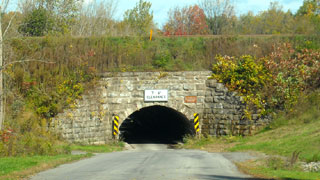
Culvert Road is the only place on the Canal System where the road burrows under the canal. In fact, it's in Ripley's Believe It or Not.
Built in 1823, the block-lined tunnel leaks like a sieve and is only wide enough for one car at a time.
With a 7-foot, 6-inch clearance a horse and buggy may have made it through the tunnel, but a rider would have to dismount and walk.
Today's cars can make it through one at a time. Fortunately it's not a heavily traveled road because the sightlines are very limited.
A sign on the towpath reads, "Directly under your feet is the Medina Culvert, built in 1823. It's located about 1 3/4 miles east of Medina and can be reached by the towpath or via Culvert Road. A culvert was chosen as more economical than a bridge because the canal crosses a valley here on a berm, and the surrounding land is some 20 feet lower than the canal."


Somewhere Between Culvert Road and Knowlesville -- There's a Moose?!?!?
Day 2
8:24 am
Total Hrs: 5.4
Avg. Speed: 8
GPS:
43.239974
-78.325646
It had to happen. Last time I checked with the New York State Department of Environmental Conservation there were no moose here.
However, plywood and black paint are widely available.

Knowlesville
Day 2
8:30 am
Total Hrs: 5.5
Avg. Speed: 8
Temp: 80 degrees
Wind: Calm
Skies: Clearing
GPS:
43.242810
-78.310170
The lift bridge at Knowlesville is away from it all. There is a very small wall on the east side of the bridge. No power, water, or facilities.
The lift bridge operator travels between this bridge and Medina so there may be a wait while he drives from one to the other.
It's shaping up to be a perfect summer day!

Eagle Harbor
Day 2
8:55 am
Total Hrs: 5.9
Avg. Speed: 8
GPS:
43.251936
--78.252935
Coordinate with the lift bridge operator prior to Eagle Harbor (or ask the Knowlesville/Medina op to call ahead) because the Eagle Harbor operator also travels to the two bridges at Albion.
There is a very short wall south and west of the bridge. No power, water, or facilities. It is a good stop for a doggie walk and a cold lunch, but not for us. Heck, we've only been moving for an hour!
Albion
Day 2
9:20 am
Total Hrs: 6.3
Avg. Speed: 8
GPS:
43.249041
-78.193771
Albion has two lift bridges. The Main Street bridge is east; Ingersoll is to the west. The bridge operator handles these and the Eagle Harbor bridge, so there may be a wait while (s)he drives from one to the next. There is definitely a wait between Main and Ingersoll, but it's usually no more than five minutes; Just enough time for the bridge operator to travel from one to the other.
Between the bridges is a wonderful little canal front with plenty of wall space, power and water. The facilities are inside the fire hall.